Lot 253 , MAPS: Lewis, Samuel. Lewis’ Map of England and Wales [&] Scotland, 4 vols. only (of 7), hand-coloured, linen-backed, in sections, each within contemporary green straight-grain morocco, gilt, [c.1840]. Sold with George an
![MAPS: Lewis, Samuel. Lewis’ Map of England and Wales [&] Scotland, 4 vols. only (of 7), hand-coloured, linen-backed, in sections, each within contemporary green straight-grain morocco, gilt, [c.1840]. Sold with George an](/full/082/90088082_Catalog_sPWuhPekmY.JPG "MAPS: Lewis, Samuel. Lewis’ Map of England and Wales [&] Scotland, 4 vols. only (of 7), hand-coloured, linen-backed, in sections, each within contemporary green straight-grain morocco, gilt, [c.1840]. Sold with George an")
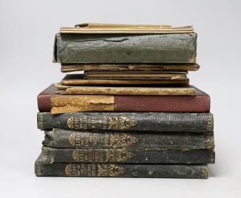
° MAPS: Lewis, Samuel. Lewis’ Map of England and Wales [&] Scotland, 4 vols. only (of 7), hand-coloured, linen-backed, in sections, each within contemporary green straight-grain morocco, gilt, [c.1840]. Sold with George and Peter Anderson’s ‘Guide to the Highlands’ (5 maps), and C. Smith’s ‘A New Map of the County of Wilts’, 1818, and J. and C. Walker’s ‘Warwickshire’, 1836, and Thomas Dix’s ‘A New Map of the County of Rutland’, 1830, and five others (17).
£50-80
Condition:
Lewis- spines worn, upper cover detached from one volume, some damp-staining and spotting to linen, maps gen. clean.
Sold for £45